This series has moved steadily forward through the procedures and regulations for IFR approved GPS units over the past few months: we have arrived finally at the use of GPS equipment for instrument approaches.
As you might anticipate, there is a large body of restrictions and regulations that applies, reflecting the somewhat ambiguous relationship the FAA has established with GPS. On the one hand, the feds appear to love the system, on the other, they have clearly expressed reservations about how much anyone should rely on it.
Here is the official position:
1. Precision GPS approaches are not authorized.
2. Aircraft using GPS navigation equipment under IFR must be equipped with an…alternate means of navigation appropriate to the flight. [AIM 1-1-20 e.1.(b)]
3. A non-GPS approach procedure must exist at the alternate airport when one is required. [AIM 1-1-20 f. 6.(h)]
The first restriction--the inability to provide precision approach guidance--results from GPS inaccuracy, a flaw that will only be overcome by FAA installation of additional hardware (WAAS). It is beyond the scope of this series to explain how WAAS improves accuracy; for now, it is enough to say that the FAA treasury will not stretch far enough to pay for it.
Restrictions (2) and (3) can be best understood by consulting a further paragraph of the AIM [1-1-20 f.8.(c)(4)]:
"GPS is a SUPPLEMENTAL NAVIGATION SYSTEM [my caps] in part due to signal availability. There will be times when your system will not receive enough satellites with proper geometry to provide accurate positioning or sufficient integrity.
"Procedures should be established by the pilot in the event that GPS outages occur.
"In these situations, the pilot should rely on other approved equipment, delay departure, reroute, or discontinue IFR operations."
Given the widespread popular enthusiasm--fervor might come closer--for GPS, I'm not sure how many pilots really consider the implications of this paragraph. If you are in doubt what the FAA means, here is a restatement:
BEWARE. YOU ARE OPERATING IN NON-VISUAL CONDITIONS WITH EQUIPMENT KNOWN TO BE PRONE TO FAILURE. TAKE APPROPRIATE PRECAUTIONS.
Appropriate precautions include the possible necessity of being ready to "discontinue IFR operations," conceivably in the middle of an GPS approach.
From all of this, it appears the FAA rates the probability of failure higher with GPS than with prior IFR systems. Provided that seems OK to you, let's go.
GPS APPROACH DESIGN
IFR GPS approaches come in two basic variants. Those that will seem most familiar have plan views ("top views") that look identical to approaches that use more standard nav aids: VORs or NDBs. When the flight track of an aircraft on one of these GPS approaches is viewed by an outside observer, it appears identical to that flown on a conventional approach: there is nothing to indicate which form of navigation is in use.
The second GPS variant--the Basic or Modified "T" design.--differs significantly.
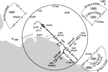
The accompanying illustration is a basic "T" at Long Beach airport in California. The format illustrates an important advantage of GPS for the approach designer. Conventional approaches use ground based navaids whose location is often dictated by mundane considerations like, "Whose back yard can we put this in?" That in turn leads to extensive differences among individual approaches. GPS is free of such limitations, and approach designers are at liberty to produce procedures based on a common template.
While the format will seem unfamiliar at first, the similarity among all such approaches all across the country will soon create the same comfortable familiarity of design and performance currently enjoyed on ILS procedures.
MISSED APPROACH POINT
Regardless of format, all GPS approach charts present several important differences from conventional approaches: most striking, perhaps, is the importance given to the Missed Approach Waypoint (MAP).
GPS approach nav is always done in Leg mode, and as you may remember from last month's column, legs are always navigated to waypoints, never from.
For this reason, the final approach segment on GPS approaches is always flown to a missed approach waypoint, not away from an FAF, as is so often the case with conventional approaches. In the Long Beach illustration, the MAP is named RW30 (Runway 30).
You will also see a number of very awkwardly named waypoints, like IWMUD and ETWAB. Many of these are specific to the GPS approach and are not part of any other procedure.
APPROACH DATA
IFR GPS units depend on two library resources: an almanac of satellite position and a database of the exact latitude/longitude locations of every key IFR waypoint. When you use GPS equipment for IFR operations, every waypoint you select must exist in that database.
For enroute operations you have a choice of waypoints, and, with the approval of ATC, you naturally choose the individual ones that will form the route you have elected to follow.
When it comes to IFR approaches, waypoint selection changes. Every approach procedure is held in the GPS database as a complete unit, starting with an initial approach fix (IAF) and extending through every intermediate fix all the way to the missed approach point (MAP) and beyond to the missed approach. As you progress through the procedure, the individual waypoints that form the backbone of the approach are checked off automatically, one by one, as you pass over them. With each waypoint passage, a new GPS course is drawn to the next, and nav indicators automatically take up the task of displaying your position relative to that new course. This process is called automatic waypoint sequencing.
There are only two exceptions to this automatic process: procedure turns and missed approach procedures.
Automatic waypoint sequencing has strengths and weaknesses. On the plus side, as long as the approach is proceeding as planned, automatic sequencing is quite convenient: it saves time and eliminates user error. No matter how hard you try, you cannot make an inaccurate bearing selection, mis-program a final approach course, or misplace a key approach fix.
On the other hand, waypoint sequencing has a major disadvantage: it's automatic, which means that, once started, you have limited control over the process. As an example of the trouble this can cause, if you make the mistake of telling the GPS unit to ACTIVATE an approach procedure too soon, perhaps during vectoring, the computer under some circumstances can mistakenly assume the approach has started and begin trying to take you where you do not want to go.
This can be quite disconcerting. Casting about for analogies, here is one that come to mind: your cruise control refuses to turn off on the freeway. The solution for the GPS in this circumstance is a bit like turning your car ignition off and on again: start over by reprogramming the entire approach.
Similarly, automatic sequencing can be troublesome if ATC changes its mind after issuing approach clearance and decides to initiate delay vectoring. If the pilot has already activated the approach on the GPS, automatic sequencing will have begun. As above, the easiest way out is to reprogram.
Which brings us, neatly, to programming.
PROGRAMMING STEPS
Approach programming has become mercifully simplified in newer GPS units. Once you have specified an airport as a final waypoint, you will find menus that offer all approach variants, including IAF and vector (when available) options for each. Even DME arcs are included, with a peculiar naming convention: the arc will be identified with the five letter identifier of its IAF, followed by one more letter. This last character establishes the arc radius by its numeric position in the alphabet: "j" = 10 nm, "O" = 15, etc.
When you have selected the approach and IAF/vector option that most appeals to you, the next step is to "load" it so that it becomes part of your active flight plan. Although the terminology may differ, this event is common to all units.
One last crucial step remains: you must remember to ACTIVATE or ARM the procedure. Without this action, the unit will not begin automatic waypoint sequencing and will not provide guidance on the approach.
As suggested above, it is important to delay activation until you are confident that automatic sequencing will not become a problem: the most common-sense recommendation is to delay until you receive approach clearance.
Regardless how long you choose to delay, activation must take place prior to arrival at the FAF. If you fail to activate by this point, automatic sequencing and guidance will not occur, and a missed approach and full retry will become necessary.
GPS MODES
As you approach your destination, even without an approach loaded, the GPS will begin to fine tune your location by making the course deviation indicator (CDI) increasingly sensitive. Enroute, CDI sensitivity is five miles, center to edge. At thirty miles from the destination airport, CDI scaling gradually decreases to one mile, center to edge (Terminal mode). Finally, within two miles of the FAF, a last shift occurs and scaling starts gradually to decrease again, this time to three tenths of a mile, center to edge (Approach mode).
At each of these points, you should see an annunciator telling you the mode in which the unit is operating.
BEFORE THE APPROACH
In addition to actual approaches, GPS databases contain IFR departure and arrival procedures. The action of selecting and loading one of these adds its waypoints to the active flight plan. An additional activation step is not required.
That wraps up a general overview of GPS approaches. I have certainly not provided enough data to permit readers to charge out and start flying them, but there should be sufficient information to get started. I recommend beginning with a computer based simulator, such as the ones provided by Garmin.
In the next and final installment, I'll look at GPS holding patterns, procedure turns, missed approaches and emergencies.
NEXT